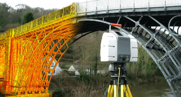
 If you happen to work with point clouds, and if you’ve ever found accessing, sharing and using that point cloud data troublesome, there’s a good chance Helsinki-based 3point, the company behind cloud service Pointscene could provide a solution for your problems.
If you don’t know anything about point clouds, however, or you have no idea what LiDAR is, there’s nothing to worry about. This is a good chance to learn something new about laser mapping, laser data storage and lasers, so that one day you can demonstrate this fresh knowledge to some poor soul who’s unfortunate enough to engage you in small talk.
Seriously though, cloud points can be an invaluable tool for those who know how to use it and Pointscene works as an on-the-go workshop and storage of those point cloud datasets. For those of you who don’t know, point clouds are essentially coordinated data points of any surface generated using LiDAR technology, AKA light detection and ranging. In short, LiDAR creates 3D scans of a designated space by analysing the reflection of a laser pulse. The image below might help you better picture what we’re talking about.

Most of larger-scale surface mapping happens with lasers these days, so that in mind Pointscene wants to spread the word and make point cloud data available for the larger public. The solution they came up with is a user-friendly cloud platform where users can easily upload, access and play around with their point clouds data sets.
For example, public sector engineers will know how many trips back and forth between the site and the office can be needed just for getting some rough spatial measurements during initial planning. With Pointscene those measurements are only a few clicks away, and accuracy goes as far as the point cloud data allows for. Elements within the data, such as trees or power lines, can be emphasised by giving them a specific class and then assigning that class with a bright colour that facilitates its visualisation. Other parameters feature options such as colouring by RGB, intensity, elevation and classification.
Another Pointscene feature comes in handy if attention needs to be drawn to specific spots within the point cloud data set: go to your spot, generate a link and share it to other users who will then be taken to that specific location.
But it still seems a bit farfetched to say an amateur would make much sense of any of this. Pointscene CTO Jonne Davidsson explained in an interview with SPAR that a major contributor in making Pointscene’s point clouds more approachable for the unexperienced eye is the fact that data is drawn in an adaptive point size, which helps in visually actually distinguishing the surfaces. Additionally, drawing in adaptive point size saves an entire processing step: “Previously, it’s been necessary to model the environment before you can visualise it in 3D, so now we can skip that step and have the data more rapidly. The environment is based only on point data”, Davidsson told SPAR.

According to Pointscene, the platform is intuitive enough for anyone to learn the ropes as soon as they open up the interface, meaning previous knowledge of point cloud is not a pre-requisite in order to use the features offered by the platform. The beauty of it is that no specific or custom-made software to use the platform is required, and no additional plug-ins need be installed either: all you really need is a browser like Google chrome or Firefox (and an active subscription).
Pointscene is targeting mainly SME’s who deal with any type of point cloud data in their projects. Theoretically, the cheapest you could go is €25 a month/user, which on top of the many features within the platform will get you one terabyte of space for your point cloud data (which should be enough). This however means you would have to go with the 100+ users package. For a team of five the cost is a heftier €95 a month/ user. Here you can find a more comprehensive pricing range.
Top image courtesy of Rudi//3D modelling


